By the President of the United States of America
A Proclamation
Whereas the Acting Secretary of the Interior has submitted to me for approval the following regulation adopted by him, after notice and public procedure pursuant to section 4 of the Administrative Procedure Act of June 11, 1946 (60 Stat. 238), under authority of the Migratory Bird Treaty Act of July 3, 1918 (40 Stat. 755, 16 U.S.C. 704), and Reorganization Plan No. II (53 Stat. 1431):
REGULATION DESIGNATING AS CLOSED AREA CERTAIN LANDS AND WATERS WITHIN, ADJACENT TO, OR IN THE VICINITY OF THE SANIBEL NATIONAL WILDLIFE REFUGE, FLORIDA
By virtue of and pursuant to the authority contained in section 3 of the Migratory Bird Treaty Act of July 3, 1918 (40 Stat. 755, 16 U.S.C. 704), Reorganization Plan No. II (53 Stat. 1431), and in accordance with the provisions of section 4 of the Administrative Procedure Act of June 11, 1946 (60 Stat. 238), I, Oscar L. Chapman, Acting Secretary of the Interior, having due regard to the zones of temperature and to the distribution, abundance, economic value, breeding habits, and times and lines of flight of the migratory birds included in the terms of the conventions between the United States and Great Britain for the protection of migratory birds, concluded August 16, 1916, and between the United States and the United Mexican States for the protection of migratory birds and game mammals, concluded February 7, 1936, do hereby designate as closed area, effective thirty days after publication in the Federal Register, in or on which pursuing, hunting, taking, capturing, or killing of migratory birds, or attempting to take, capture, or kill migratory birds is not permitted, all areas of land and water in Lee County, Florida, not now owned or controlled by the United States within the following-described exterior boundary:
Beginning at low water east of Sanibel Island Light, situated on Point Ybel on the east end of Sanibel Island, Florida, in approximate latitude 26°27'13" N., longitude 82°00'48" W.;
Thence Northwesterly with low water along the northeast side of Sanibel Island approximately 5170 yards (2.94 miles) to a point at low water and approximately 704 yards (0.40 mile) southeast of Woodrings Point on Sanibel Island;
Thence Northwesterly, within Pine Island Sound, approximately 1760 yards (1.00 mile) to St. James Light 5, in St. James City Channel, between Sanibel and Pine Islands;
Thence Northwesterly, Southwesterly and then Northwesterly continuing through Pine Island Sound by straight lines connecting in order the following navigation markers: St. James Daybeacon 7 (black); Pine Island Sound Daybeacon 8 (red); Pine Island Sound Light 10; Pine Island Sound Daybeacon 12 (red); Pine Island Sound Daybeacon 14 (red); Pine Island Sound Daybeacon 15 (black); Pine Island Sound Light 16, approximately 11,616 yards (6.60 miles) to Wulfert Daybeacon 1 (black), at the entrance to Wulfert Channel;
Thence Westerly and Southwesterly in Wulfert Channel and between Sanibel and Captiva Islands by straight lines connecting in order the following navigation markers: Wulfert Daybeacon 3 (black); Wulfert Daybeacon 5 (black); Wulfert Daybeacon 7 (black); Horn Passage Daybeacon 2 (red), approximately 3058 yards (1.74 miles) to Horn Passage Daybeacon 3 (black);
Thence Southerly approximately 638 yards (0.36 mile) to the center of the highway bridge connecting Sanibel and Captiva Islands;
Thence Westerly with the center of bridge and the prolongation thereof, across Captiva Island approximately 506 yards (0.29 mile) to low water on the west shore of Captiva Island;
Thence Westerly at right angles to the shore of Captiva Island, 440 yards (0.25 mile) to a point in the Gulf of Mexico;
Thence Southeasterly, Easterly and then Northeasterly, in the Gulf of Mexico, parallel to and 440 yards (0.25 mile) from low water along the south shore of Captiva and Sanibel Islands approximately 24,024 yards (13.65 miles) to a point in the Gulf of Mexico;
Thence Northwesterly 440 yards (0.25 mile) to the place of Beginning.
In Witness Whereof, I have hereunto subscribed my name and caused the seal of the Department of the Interior to be affixed this tenth day of November 1947.
OSCAR L. CHAPMAN,
Acting Secretary of the Interior.
And Whereas upon consideration it appears that the foregoing regulation will tend to effectuate the purposes of the aforesaid Migratory Bird Treaty Act of July 3, 1918:
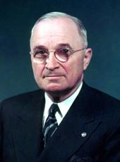
Now, Therefore, I, Harry S. Truman, President of the United States of America, under and by virtue of the authority vested in me by the aforesaid Migratory Bird Treaty Act of July 3, 1918, do hereby approve and proclaim the foregoing regulation of the Acting Secretary of the Interior.
In Witness Whereof, I have hereunto set my hand and caused the Seal of the United States of America to be affixed.
Done at the City of Washington this 2nd day of December in the year of our Lord nineteen hundred and forty-seven, and of the Independence of the United States of America the one hundred and seventy-second.

HARRY S. TRUMAN
By the President:
ROBERT A. LOVETT,
Acting Secretary of State.
Harry S Truman, Proclamation 2758—Closed Area Under the Migratory Bird Treaty Act: Florida Online by Gerhard Peters and John T. Woolley, The American Presidency Project https://www.presidency.ucsb.edu/node/287914

